Drones are inherently mobile and have the innate ability to capture on-demand maps at a cost much lower than traditional approaches that involve manned aircrafts. Moreover, the drone imagery is of much higher resolution than satellite or ground-based capture.

Aerial Drone Photography & Videography
Since 2013, AUAV has offered reliable, high-quality drone services, aerial mapping and accurate survey data for Victoria, Western Australia, and elsewhere around the country.
Our Photography and Videography Services
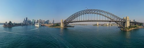
Aerial Photography
In the ever-evolving digital world, our drones capture breathtaking high-resolution aerial photographs of your assets and property as per your requirements, enabling you to gain all the benefits of computer modelling and analysis for planning or monitoring your projects.
Aerial Videography
Our drone cinematographers offer spectacular 4k high-quality drone videos that help you bring more business and increase revenue. Backed by a dedicated team of photo/video cinematographers and qualified surveyors, we at AUAV transform aerial videography and photography services into an exceptional experience that you truly deserve.




Drone Photography and Video Service Applications
Aerial videography and photography have many benefits depending on their intended use. Some most common service applications include:
Digital Marketing
Drone videography and photography can help you boost your digital marketing efforts. Drones can capture breathtaking aerial footage that can make heads turn everywhere. Adding drones in your digital marketing campaigns boosts engagement, increases traffic to your website, and generates leads.
Inspections
Drone photography and videography can deliver high-quality, actionable data safely and quickly. These detail-rich, insightful aerial photos and videos can help you make informed and actionable decisions.
Property Management and Development
Drone videos and photos can help in property management and development by capturing the construction process and the safety measures used. It also provides a clear view of the materials used, thus ensuring the security and stability of the entire construction project.
Why Use AUAV for Aerial Photos and Video?

Frequently Asked Questions
We prefer using Inspire 2 with an X5s lens for aerial photography and videography.
We record 25 or 50 fps in 4K resolution.
Unless otherwise specified by the client, we shoot photos in RAW (DNG) format and film in either MP4 or MOV format.
