AUAV is Australia’s first national-scale drone data services provider, with licensed operators undertaking work in every state each month. Our core businesses are aerial mapping/survey and aerial inspection of assets and infrastructure.
We frequently receive inquiries to provide LiDAR data, which we can certainly do, but there are two things to clarify:
- Most often what people want is a 3D point cloud or Digital Elevation Model (DEM), not specifically LiDAR data.
- Aerial LiDAR data is generally less accurate than drone aerial photogrammetry data.
There is a perception that LiDAR is the best available technology for 3D surveys, however, in our experience for most projects aerial LiDAR is less accurate, less reliably scheduled, and more expensive than a photography based approach. We’ll discuss the pros and cons of each methodology below.
Regardless of the method, in both cases a 3D point cloud or digital terrain model is the result, and either can be delivered by AUAV. Being impartial to any specific technology, we will recommend the most suitable and cost-effective approach depending on the project requirements.
What is LiDAR?
LiDAR is a form of 3D scanning using a laser rangefinder. Depending on who you ask, the name either means ‘Light Detection And Ranging’ or ‘Light Radar’. A LiDAR sensor fires out thousands of laser rays per second in a scanning pattern, rapidly sampling distances through its arc of movement.
Terrestrial LiDAR (i.e. sitting on the ground), is a well-established technology for accurately measuring and scanning 3D forms, whether that is terrain, buildings, infrastructure, vehicles or even people. Terrestrial LiDAR combines an incredibly accurate distance measurement from the laser rangefinder with very accurate measurements of both the scanner’s position and also the angular direction the laser is pointing in at any given moment. The combination of these 3 highly accurate measurements means that the end product is a dense 3D dataset which is accurate to the sub-centimetre level (sometimes even to the millimetre level, over short distances).
Aerial LiDAR
Aerial LiDAR involves putting a similar laser scanning sensor in the air, either on a full size (manned) aircraft, or Unmanned Aerial Vehicle (UAV, more commonly referred to as a ‘drone’).
Mounting the LiDAR unit in the air opens up two very attractive capabilities:
- You can scan downward from a broad overhead view, making it much easier to scan terrain. In comparison, terrestrial LiDAR will need to use multiple scanning positions to cover a large area, and even then may not be able to cover features such as steep gullies and cliffs.
- You can cover a large area in a short period of time.
Unfortunately, there are also two significant downsides to aerial LiDAR :
- Cost. Professional aerial LiDAR sensors currently cost between hundreds of thousands and millions of dollars, and are quickly obsolete as the technology improves. This means that their purchase price needs to be amortised across any projects using them at a very high rate, making it an expensive service.
- Accuracy. Aerial LiDAR uses a very accurate distance measuring device, but this is reliant upon relatively inaccurate position and angular measurements. This means the final data is of comparatively lower accuracy (usually in the range of 15-20cm).
The reason why the accuracy is so much lower than Terrestrial LiDAR is that in the air you don’t know precisely where you are or precisely where the laser is pointing. LiDAR works by scanning progressively through the scene (as opposed to taking a complete ‘snapshot’ of the scene at one moment), so any discrepancy in its movement during the scan will distort the resulting data.
The positional information can be made more accurate if using RTK GPS systems (as we use in some of our high-end drones). A much bigger problem though is the angular measurement. Assuming you did know precisely where the sensor is, using even top of the range military-spec angular measurement sensors, the best you can generally obtain is in the order of 1/100th of a degree. This sounds quite precise but results in a large error when you are flying high over a site. For a typical manned aircraft LiDAR mission at an altitude of 3000ft for example, an offset of 1/100th of a degree results in a 16cm error on the ground, and most systems are using much less accurate angular sensors than that. Lightweight sensors currently used on drones are typically unable to achieve better than 1/10th of a degree angular error.
From an academic standpoint there is a good paper here studying the cumulative effects of different variables in airborne LiDAR, concluding the accuracy range as being 15-37cm as a general rule of thumb.
There are new SLAM based LiDAR technologies in development which can avoid the reliance on such accurate positional and angular measurements, but for the moment current LiDAR technology is limited by these accuracy factors.
3D Point Cloud Data
The output of a LiDAR scanner is a dense cloud of 3D points. Sometimes a lot of effort and human judgement is required to turn the raw data from the sensor into an accurate 3D model, but assuming this has been done sufficiently well then the end product is a good representation of the area being scanned (accurate to sub-centimetre in the case of terrestrial LiDAR, or approximately 15-20cm in the case of aerial LiDAR).
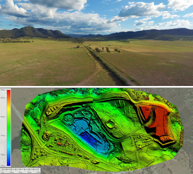
Another consideration for LiDAR is that the data is only sampling positions, not colour. This yields a monochrome dataset which can be difficult to interpret. This is commonly visualised using false-colour to indicate elevation (as seen on the left), which helps to make it more meaningful.
It is possible to overlay colour information onto the LiDAR data afterwards from another source, for example using photos taken by a camera mounted on the LiDAR scanner or alongside it, but this can be an imprecise process due to mixing capture methods: the LiDAR data itself is not captured in colour.
However, LiDAR isn’t the only source of point cloud data.
Photogrammetry vs LiDAR
Photogrammetry is the process of generating accurate maps, models and measurements from photographic imagery. In the past this was limited to rectifying aerial images in order to take accurate measurements from them, a process going back to the early days of aerial reconnaissance over enemy lines in World War I.
In recent years though there have been major advancements in photogrammetry, enabled by software breakthroughs, availability of powerful computing resources, and more accessible aerial imagery from drones.
When provided with high-quality image data, modern photogrammetry can generate very accurate 3D models, with two distinct advantages:
- The 3D models from photogrammetry surveys are in most cases more accurate than aerial LiDAR (usually +/- 5cm, or better if required).
- The 3D models and point cloud data generated from photogrammetry is in full colour, making them much more easily visualised and interpreted. You also get a 2D colour map out of the same process.
The improved accuracy comes from each photo being a complete and precise record of everything seen within the frame, so it doesn’t require such accurate positional and directional sensor information. Within each image, there is always a precise relationship between the angles of different pixels in the image at a given distance, so there is no chance of inaccuracy within an image once you understand the internal lens and camera parameters.
The only source of potential error comes from the process of stitching together many different images (usually hundreds, but often thousands of images for large areas) to make the 3D model. However, this can be countered by a high-degree of image overlap and the use of Ground Control Points (GCPs). GCPs are a sparse array of positions marked and surveyed on the ground, visible in the aerial imagery, to which the data is precisely fitted during the processing stage. This ensures that the entire 3D model is ‘survey grade’ accurate, i.e. usually ~5cm across the site, but it is possible to increase this accuracy, which has been demonstrated to as high as 5mm accuracy.
Limitations of Aerial Photogrammetry
One area which can be problematic for photogrammetry is dense vegetation. For most projects we specify that the results of our aerial surveys will be accurate while the density of vegetation cover is below about 60%. LiDAR does have a similar limitation, though it can more effectively see through vegetation, up to perhaps 90% canopy cover, due to it firing so many laser samples that many of these get through the small gaps to the terrain below.
In both cases the resulting 3D Digital Surface Model (DSM) will include both the trees and the terrain, but it is possible to remove the trees to then be left with a clean Digital Terrain Model (DTM), provided you have sufficient open space visible between the trees to interpolate from.
Vegetation also affects accuracies on a smaller scale, for both photogrammetry and LiDAR, in that dense short vegetation (i.e grass, dense crops) will result in the survey being at the height of the vegetation rather than the terrain. This can cause inconsistencies between recurring surveys, for example if grass is mown or crops harvested in between.
Due to photogrammetry relying on each point being seen and correlated between multiple sources, it can also have difficulty in some very uniform/homogenous areas, for example crops such as corn or sugarcane at full height. In most cases though, even if an area looks very uniform to your eye at ground level (e.g. sand, snow, salt flats) there is usually ample variation when seen on a larger scale from above, so this is rarely an issue.
Finally, water bodies are not accurately captured by either photogrammetry or LiDAR , however this is not a problem as you can interpolate from the nearest shoreline, given water is effectively always a level surface.
Conclusions: AUAV and Aerial LiDAR
Although we feel that LiDAR is not the best choice in most scenarios, it can still be a good option if the project has lower accuracy requirements and:
- Requires a terrain model through thick (60-90%) vegetation cover; or
- Needs to cover a very large area (5000+ ha).
AUAV has multiple options for delivering aerial LiDAR data using drones to tackle small areas with thick vegetation cover, and we also collaborate with manned aerial LiDAR service providers who we can subcontract to supply us with the base data, from which we can then process the final deliverables (e.g. 0.5m contours).
Additionally, we feel the technology of UAV-based LiDAR will soon improve to the point where it is an affordable solution giving similar accuracy to photogrammetry. Driverless cars are also pushing the need for more accurate and affordable vehicle-mounted LiDAR sensors, which the drone industry will benefit from, so the pace of this development is accelerating. We continue to keep our eyes on the latest developments, and are in contact with a number of vendors and universities working on these solutions. As the technology matures we will be first in line to move ahead with new sensors.
In the meantime though, we recommend a photogrammetry approach for around 95% of projects we are involved with, and can easily provide LiDAR data for the remaining 5% if the project’s budget allows.
