Drone aerial data can be an incredibly powerful tool, but as with other technologies it is important to use it in the right way and with some knowledge about its strengths and limitations.
AUAV has surveyors on staff and we understand the challenges and limitations of aerial data. We have been performing these services for 5+ years and have been involved in many validation tests with traditional survey methods, so we have a deep understanding of the issues. If you have any further questions on this topic, please feel free to get in touch and we’ll get you an answer and also update the information here to cover it.
Mapping-Grade vs Survey-Grade Accuracy
To start with it helps to consider two broad categories of aerial data accuracy:
- Aerial Mapping produces results which are visually accurate.
- Aerial Survey produces results which are measurably accurate.
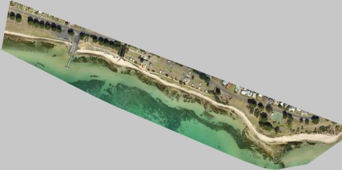
Mapping-grade accuracy uses only the drone’s on-board GPS for positioning information, and so tends to be accurate to a few metres horizontally but not in terms of elevation. Mapping-grade data is suitable for things like vegetation and environmental assessment, a visual site plan, or any other purpose where you only need to look and point at the map, count things or assess relative sizes rather than taking precise measurements or coordinates. These outputs look correct to your eye, but if you were to take measurements from the map and correlate them with measurements on the ground you would find there can be some quite large inaccuracies (typically several metres horizontally, and even as much as tens of metres vertically).
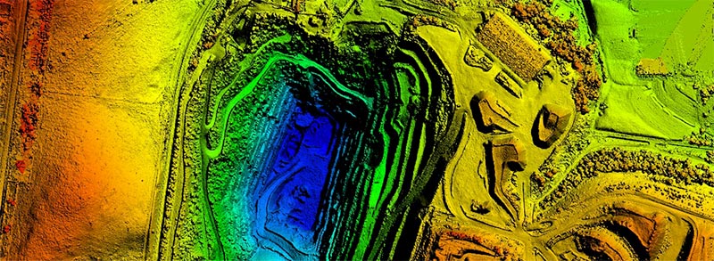
Survey-grade data is required in cases where accurate distance, area, elevation and volume calculations are required, such as Digital Elevation Models (DEM) or point clouds for stockpile volumes, drainage design, site planning and engineering projects. For typical survey projects the accuracy of aerial drone data is +/- 50mm lateral and 50-80mm vertical (though any range of accuracy is possible, see ‘Variable Accuracy’ below).
To obtain survey-grade data it is necessary to first place Ground Control Points (GCPs) in a grid around the site and to measure these positions to <2cm accuracy (which requires professional survey equipment, not a normal GPS or your iPhone!). These visual targets are then captured and tagged in the aerial imagery during data processing so that the resulting DEM is tightly fitted to these positions, ensuring accuracy throughout the survey area.
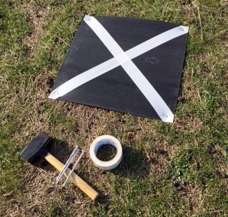
Placing and surveying the GCPs can often take us more time on site than is required to fly the aerial data capture, but is a necessary step to both ensure and validate the resulting data accuracy. Over the past 5 years AUAV has built up a good working knowledge of how much ground control is required and where best to place them in order to guarantee the accuracy of our results.
Variable Accuravy (i.e. Anything in Between)
As well as our standard 50mm survey accuracy, it is possible to push this to greater precision in some cases. Accuracy of 20mm or better is possible, though it tends to only be feasible for small areas (e.g. engineering projects such as a bridge or tower, i.e. up to a few hundred meters in scale).
Likewise, if you require less precision but still need some degree of known and verifiable accuracy then it is possible to use sparser ground control, for example to achieve a 25cm accuracy which is suitable for the 0.5m contours typically used in flood modelling and similar purposes.
What tends to work best is to discuss your accuracy requirements with us (or any suitably qualified aerial survey company) so that we can best fit the precision to your needs. There is a direct trade-off between accuracy and cost, so it literally pays to not over-specify accuracy requirements.
Vegetation
Aerial survey accuracy metrics are always given relative to bare terrain, e.g. earthworks, rock, roadways and the built environment. Vegetation is a cause for inaccuracy because with aerial survey, what you see from above is what you get in the resulting elevation data.
As an example, if you were surveying a golf course fairway or short-cropped pasture you would expect the elevation data to be uniformly 3-6cm higher than the underlying terrain and can therefore be easily accounted for.
However, in cases of dense and mixed vegetation this is not so easy to correct for. In cases of thick and variable ground cover unfortunately you cannot obtain an accurate survey of the underlying terrain, as it is simply not visible from above. Depending on the capture technique, different levels of vegetation cover can be accommodated: with photogrammetry-based approaches (the most common and efficient, based on photographic images) there is a limit of about 60% ground or canopy cover. For LiDAR (i.e. aerial laser scanning) this increases to be able to deal with about 85% cover and still recover the terrain below.
Sparse trees can be removed from the aerial survey, and the holes interpolated to produce a clean terrain survey (see ‘Digital Terrain Model’ below). Please note that this removal is an additional cost in most cases, as the base expectation is that we are providing a complete survey of everything including the vegetation.
This is only an issue if you need a survey of the underlying terrain. If you are happy to have the vegetation included in the survey data, then it poses no problem (and in many cases, the vegetation can be a point of interest for the survey, such as forestry and environmental work).
DEM vs DSM vs DTM
These 3 terms overlap and can get a bit confusing, and to be honest there is no completely authoritative definition in the industry, but below is how we define them at AUAV.
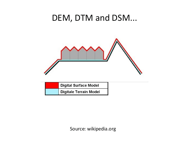
Digital Elevation Model (DEM) and Digital Surface Model (DSM): these terms are synonymous and refer to an elevation model defining the highest point at each surface location, regardless of what that surface is (i.e. terrain, buildings or vegetation).
Digital Terrain Model (DTM): this is the special case, being an elevation model of the underlying terrain only, removing any buildings or vegetation above it. A DTM is more complex to produce as it requires a combination of automated software and manual work to remove and re-validate the elevation model. There is no magic solution for removing just what you don’t want and keeping what you do. For example it is easy to accidentally remove or reduce stockpiles in the process of removing nearby trees if you let the software go too far. It requires quite a bit of practice and always some manual effort to remove things without adversely affecting the other data.
RTK and Ground Control
Many drone manufacturers promise that using ‘RTK’ (Real-Time Kinematic) positioning systems on board can give survey-grade accuracy without the need for any Ground Control Points (GCPs). A similar solution known as ‘PPK’ (Post Processed Kinematic) gives the same result but processing the corrections afterwards rather than (literally) ‘on the fly’.
At AUAV we have both RTK and non-RTK systems in use, and we would love it if this was true given that more than half the time we spend in the field is dealing with GCPs, but we have found that it is not quite the case with current technology and some ground control is always required, if only for QC validation.
It is true that RTK-enabled systems require less Ground Control, but it doesn’t completely negate the need for it. In order for a system to not require any ground control it would need:
- A near-perfect GNSS positioning system (which is almost the case with RTK/PPK).
- A near-perfect IMU orientation system (not the case with current technology, even with military-grade systems).
- A near-perfectly calibrated camera trigger timing system (i.e. the known delay between a trigger event and the camera taking the picture, taking into account all variables).
- A near-perfectly calibrated camera optical system (available in high-end manned aerial survey camera systems, and some other niche systems, but certainly not in the current commercial drone camera systems).
- A near-perfectly calibrated camera mount (i.e. the angle between the camera and the aircraft to a fraction of a degree).
- No human error at various stages of the data processing pipeline.
Currently about half those requirements are unresolved, so although we can know exactly where the drone and camera were at the time it triggered the sensor, it doesn’t then mean we can know exactly where each pixel of the resulting image lies on the ground below.
In any case, even if all the above were perfect, there would still be a need for some ground control to validate the accuracy of the results. If you aren’t taking any measurements on the ground then you can only trust that a long sequence of highly technical steps has gone perfectly to plan, with no technical or human error. A very simple solution is a minimal set of ground control points to at least validate the results, and more depending on the capability of the system and your findings when validating the accuracy, using check-points as you reduce the amount of ground control in a series of tests.
Summary
Drone aerial mapping and aerial survey are powerful tools, and can provide a complete solution for many industries and projects where there is a tight fit between the accuracy and limitations and requirements. However, there are limitations and it is important to know these and be sure the results will be fit for purpose.
For a small number of precise samples (e.g. cadastral boundaries) drone data is not appropriate, but for covering larger areas such as new subdivision or solar farm developments, mining and quarries, cliff geotech surveys and myriad other uses, it is the perfect technology.
Please contact us to discuss your requirements, and with the benefit of our 5+ years of experience and surveyors on staff, you can be sure we will discuss openly and honestly what can be achieved, where the limitations may lie, and whether alternative approaches may be suitable.

